Typhoon Mangkhut has made landfall in China’s Guangdong, after wreaking havoc in Hong Kong and Macau, and killing at least 49 people in the Philippines.
The world's biggest storm this year has left a trail of destruction in the Philippines and Hong Kong, before making landfall in China's most populous province, Guangdong.
Packing gale force winds of more than 200 kph, tropical cyclone Mangkhut is considered the strongest to hit the region this year.
The typhoon, dubbed the “King of Storms” by Chinese media, made landfall in Haiyan town at 5:00 p.m. local time, packing winds of more than 160 kph, weather officials said.
Ports, oil refineries and industrial plants in the area have been shut. Power to some areas were also reduced as a precaution. In Shenzhen, electricity supply to more than 130,000 homes was cut at one point on Sunday.
The storm has fueled concern about sugar production in Guangdong, which accounts for a tenth of national output, at about 1 million tonnes. China sugar futures rose last week on fears for the cane crop.
Guangdong is also China’s most populous province, with a population of more than 100 million.
Here are some facts about monster storms and what to expect as climate change supercharges our weather.
A cyclone by any other name
Hurricanes, cyclones, and typhoons are different names for the same type of giant tropical storms that form in oceans near the Americas and Asia.
Bringing torrential rains, high winds, storm surges, and giant waves, the storms can be deadly and wreak havoc once they make land.
At their most fearsome, these low-pressure weather fronts pack more power than the energy released by the atomic bomb that levelled Hiroshima.
READ MORE
In the Atlantic and northeast Pacific, they are known as hurricanes, while typhoon is the term used in Pacific Asia. The same weather phenomenon in the South Pacific and Indian Ocean is a cyclone.
Humble beginnings
Cyclones start life as simple thunderstorms. But at certain times of the year, when sea temperatures are high enough to create evaporation, the storm fronts begin to suck up vast quantities of water.
In the northern hemisphere they are pulled into an anti-clockwise spiral as they make their way across the ocean by the rotation of the Earth. Cyclones in the southern hemisphere rotate clockwise.
The water they hold is then deposited as rainfall, bringing catastrophic flooding, property damage and loss of life.
The storms themselves - with a calm "eye" at their centre - can measure up to 1,000 kilometres across.
But they weaken rapidly when they travel over land or colder ocean waters.

AAP
Size doesn't (always) matter
Scientists rank cyclones from Category 1-5. Category 5 storms have sustained winds of at least 252 kilometres per hour or higher.
Recent Category 5s include Hurricane Irma, which battered the Caribbean and the southern United States in September 2017.
Hurricane Katrina, which killed over 1,800 people across the US Gulf Coast in 2005, was also a Category 5.
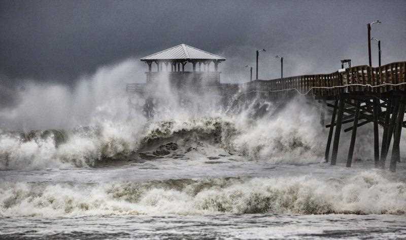
In contrast, Florence weakened on Thursday to a Category 2 event, although that is not to say it is not still extremely dangerous.
Florence is forecast to dump up to 100 centimetres of rain in some areas after making landfall in North and South Carolina Thursday night or Friday.
AAP
"We're expecting 500-1,000 millimetres in Jacksonville, where the average monthly rainfall is 180-200 mm," Emmanuel Bocrie, forecaster at the Meteo France weather service, told AFP.
"So a lower category storm can still be dangerous and do a lot of damage."
A summer of violence
Last year saw a string of catastrophic storms batter the west Atlantic - including Irma, Maria and Hurricane Harvey - causing a record-equalling $125 billion (107 billion euros) in damages when it flooded the Houston metropolitan area.
Bocrie said 2017 was exceptional for Atlantic superstorms as surface water temperatures were on average two-to-three degrees Celsius warmer than normal.
For this hurricane season, the NOAA forecasting service and Britain's Met Office predict between five and nine storms of Category 3 or stronger.
READ MORE
"That's a relatively normal season," according to Bocrie. "But be careful. That's not to say we can rule out a disaster, it only takes one."
Worse to come?
Scientists have long predicted that global warming will make cyclones more destructive, and some say the evidence for this may already be visible.
Warmer oceans add to the raw fuel on which cyclones feed, and higher sea levels boost storm surges that may overcome coastal defences.
Cyclones "are going to be far stronger, more violent and destructive, and we expect more rain as well," said Bocrie.
Source: AFP - SBS